Barrhaven | |
|---|---|
Suburb | |
 A group of homes in Barrhaven on Woodroffe Avenue, between Fallowfield Road and Earl Mulligan Drive | |
 Barrhaven Location of Barrhaven in Ottawa | |
| Coordinates: 45°16′30″N 75°45′00″W / 45.27500°N 75.75000°W | |
| Country | Canada |
| Province | Ontario |
| City | Ottawa |
| Established | 1968 |
| Incorporated | 1978 |
| Amalgamated | 2001 |
| Government | |
| • Mayor | Mark Sutcliffe |
| • City councillors | David Hill, Wilson Lo |
| • Member of Parliament | Mark Carney |
| • Member of Provincial Parliament | Tyler Watt |
| Area | |
• Total | 42.93 km2 (16.58 sq mi) |
| Elevation | 100 m (330 ft) |
| Population (2021) | |
• Total | 103,234 |
| • Density | 2,404.7/km2 (6,228/sq mi) |
| Time zone | UTC−5 (Eastern (EST)) |
| • Summer (DST) | UTC−4 (EDT) |
| Forward sortation area | K2G, K2J |
| Area code(s) | Area codes 613, 343, and 753 |
Barrhaven is a suburb of Ottawa, Ontario, Canada. It is located about 17 km (11 mi) southwest of the city's downtown core. Prior to amalgamation with Ottawa in 2001, Barrhaven was part of the City of Nepean. Its population as of the Canada 2021 Census was 103,234.[1]
Geography
[edit]Barrhaven is approximately bounded to the north by the Greenbelt, to the east by the Rideau River, to the west by Highway 416, and to the south by the new Half Moon Bay development along Cambrian Road south of the Jock River. The area is diagonally bisected by CN rail tracks. Barrhaven is surrounded by rural areas and farmland, with the exception of the growing Riverside South area across the Rideau River. Directly south of Barrhaven is Manotick, a commuter town of the city.
Barrhaven is divided into several areas: Barrhaven proper or Old Barrhaven is the westernmost part of the neighbourhood, lying between Cedarview Road and Greenbank Road. New residential development is expanding the west side of Old Barrhaven between Cedarview and Strandherd Drive. Also included in this area is a triangle of land east of Greenbank between Fallowfield Road and the railway tracks known as Knollsbrook or The Triangle. South of this is the area known as Longfields, which stretches south to Strandherd and east to Woodroffe Avenue. Sandwiched between the railway tracks, Jockvale Road, Greenbank and Strandherd is the neighbourhood of Barrhaven on the Green. East of Woodroffe, next to the Rideau River, is the neighbourhood of Davidson Heights. South of Strandherd and east of Greenbank is a new community known as Chapman Mills. As Prince of Wales Drive approaches Longfields Drive, there is a thriving community known as Stonebridge that is located beside the Stonebridge Golf & Country Club.
History
[edit]Pre-urbanization
[edit]
The Barrhaven area was long inhabited by First Nations peoples, and the modern Jockvale Road follows an ancient path that was originally a trail through the wilderness.[2][3][4] In the 19th century, the area became populated by colonial era farmers as the area was divided into a number of rural homesteads.
The old Barrhaven School House located at Jockvale and Strandherd was built in 1906. Today, the school stands as a historic site.[2] In 1911, the Canadian Northern Railway built a rail line from Ottawa to Toronto through the area. Fast passenger service was offered for many years from Fallowfield Station (near the intersection of Strandherd Dr and Cedarview Rd) to Ottawa and beyond.[5] After many years of absence, passenger rail service was reintroduced to the area by Via Rail in the fall of 2002 through a new Fallowfield Station located at the intersection of Fallowfield Road and Woodroffe Avenue.
Construction
[edit]Modern Barrhaven was established in the 1960s, one of a group of new suburbs built outside the Greenbelt from the main city of Ottawa. Building in the area was begun by Mel Barr, for whom the community is named. Barr had originally purchased a 200-acre (0.81 km2) farm with the intent of constructing a horse racing track. However the Rideau Carleton Raceway was built further to the east, and Barr instead decided to develop his land for housing. In 1968-69 Barrhaven Public School was built as the very first public school in Barrhaven.[2][3]
Barrhaven was incorporated into the City of Nepean in 1978 and subsequently grew rapidly into a community of several tens of thousands of people. Commercial centres were slower to arrive. In 1990, the area was served by a single grocery store, had no movie theatre, and not even a bar. This has changed with the opening in 1991 of the vast Barrhaven Town Centre complex of big box stores and smaller commercial establishments, as well as a few smaller shopping malls. The 1990s also saw the influx of high-tech companies into the area (such as JDS Uniphase and Nortel), and the growth of the Public Service in the National Capital Region. The area got its first high school in 1998 when Mother Teresa High School (Catholic) opened, followed by John McCrae Secondary School (public) in 1999. Barrhaven gained its third high school in 2002 when St. Joseph High School (Catholic) opened. In September 2009, Longfields-Davidson Heights Secondary School (Public) opened. In 2011, École secondaire catholique Pierre-Savard opened.
Events
[edit]In 2024, Barrhaven was the site of the city's worst mass killing in its history when six people were killed with a bladed weapon.[6]
Character
[edit]
Like most North American suburbs built so quickly and so recently, Barrhaven has a very uniform feel. Most streets consist of town houses with some streets having comparatively large suburban houses. In the older parts of Barrhaven, the streets are curvilinear, never forming a grid as they do in older parts of Ottawa.[4] Now largely hidden by trees near the Rideau River is a heritage building, now a private residence, that was once known as Stephen Collins House, and briefly as the site of Hamilton's Restaurant. The area is very suburban and tends to attract families.[7][8][9][10][11][12]
Neighbourhoods
[edit]Barrhaven is divided into many neighbourhoods. The names are generally selected by developers.
- Barrhaven (also known as Old Barrhaven) west of Greenbank, south of Fallowfield, north of the rail tracks, and east northeast of Jockvale
- Strandherd Meadows, the infill development extending Old Barrhaven to Strandherd Drive
- Longfields, east of Greenbank Road, west of Woodroffe Avenue, south of Fallowfield Road and north of Strandherd Drive
- Davidson Heights, east of Woodroffe Avenue
- Havenlea, bounded by Crestway Drive, Leikin Drive, Prince of Wales and Cresthaven Drive
- Chapman Mills, bounded by Prince of Wales Dr to the south/east, Woodroffe Ave to the west, and Stoneway Dr to the north.
- Rideau Glen, along Prince of Wales Dr, Holborn Avenue, and Rideau Glen Drive, north of Winding Way
- Winding Way, east of Prince of Wales Drive
- Stonebridge, located between Jockvale Rd and Prince of Wales
- Half Moon Bay, new neighbourhood under development along Cambrian Road, west of Greenbank, east of Highway 416, south of the Jock River and north of Barnsdale Road
- Quinn's Pointe, new community under development along Cambrian Road, west of Greenbank, north of Barnsdale Road[13]
- Barrhaven Mews, new community under construction between Strandherd Road and the Jock River and west of Jockvale/Greenbank Roads
- Barrhaven On The Green, located between Jockvale Road, Greenbank Road, Strandherd Road, and the Rail tracks
- Heart's Desire, located along the Jock River, in between Jockvale Road and Woodroffe Ave.
- West Pointe Village, located between Cedarview Rd., Fallowfield Rd., Strandherd Rd., and the Rail tracks
- Pheasant Run, west of Larkin Drive, south of Fallowfield, north of Jockvale and east of Cedarview Road
- Fraservale, south and west of Jockvale, east of Cedarview and north of rail tracks
- Knollsbrook, west and north of rail tracks, south of Fallowfield and east of Greenbank.
- Havencourt, across from South Nepean Park, east of Greenbank between the transitway and Longfields Drive.
- Havencrest, east of the intersection of Strandherd and Fallowfield and North of Jockvale Road.
Features and amenities
[edit]Barrhaven contains several public and Catholic schools and numerous parks and playgrounds, mainly built since 2000. It is also home to the Walter Baker Sports Centre which contains a library and other facilities. The main commercial district, called the Chapman Mills Marketplace, surrounds the intersection of Strandherd Drive and Greenbank Road. It hosts a seven-screen cinema, and numerous stores. The Minto Recreation Complex, a new multi-use community centre at the corner of Cambrian and Greenbank, opened in 2014.[14][15] A major employment district was established in 2015 in the area west of Strandherd Drive adjacent to Highway 416, known as the CitiGate corporate campus.[16] Along with it, a large shopping centre came, with its major tenant being a Costco.
Infrastructure
[edit]Transportation
[edit]Barrhaven is served by two bus rapid transit lines and is very near to the terminus of O-Train Line 2 at Limebank station. Several local buses run in Barrhaven, including routes 70, 73, 80, 99, 110, and 173. Routes 275, 277, and 279 only run during rush hour and (along with Transitway routes 74 and 75) connect to O-Train Line 1 at Tunney's Pasture station. There are many 600's series routes which serve the schools in the area as well.
Intercity Via Rail connections can be made at Fallowfield railway station to Montreal and Toronto.
Until 2006, it had been planned that the north–south light-rail O-Train (today's Line 2) would be extended to the centre of Barrhaven near Riocan Marketplace via Riverside South. The project was cancelled on December 14, 2006, by Ottawa City Council, which decided to focus on building rail-based rapid transit lines in the inner city instead. Rail-based rapid transit to Barrhaven is not expected to be introduced until after 2031, when the three lines in the inner city are expected to be completed.[17]
On January 2, 2007, OC Transpo opened the Strandherd Transitway station and Park & Ride lot in Barrhaven. Directly across from the Chapman Mills Marketplace Wal-Mart & TD Bank, the facility has parking space for about 330 cars. It was built to help with overcrowding at the Fallowfield Station and meet the increased demand for park and ride spaces in the community. Rapid transit route 75 takes approximately 10 minutes to travel between Fallowfield Station and Strandherd Station, and 2 minutes between Strandherd Station and Barrhaven Centre Station. The Province of Ontario funded one-third of the $5 million cost.
In April 2011, the transitway (BRT) network was expanded in Barrhaven. One feature was the extension of Route 94 (now Route 74) to the intersection of Woodroffe and Strandherd. A new stretch of BRT was also constructed between Fallowfield and Strandherd to reduce travel times on Route 95 (Route 75 since 2019).[18] In September 2014, a new BRT route was established on Chapman Mills Drive, using a graveyard median from the canceled south-western LRT route. Route 99 started at Barrhaven Centre and, using new Beatrice Station proceeded to Greenboro Station (the former O-Train Line 2 terminus) at non-peak hours via Riverside South (Vimy Memorial Bridge) and Leitrim Station. At peak hours, the 99 went all the way to Hurdman Station via the Southeast Transitway, connecting to the O-Train Line 1. Since the opening of O-Train Line 2's extension to Riverside South, route 99 has been truncated to end at Limebank station, Line 2's southern terminus, and had its frequency reduced.
Commerical centres
[edit]- Barrhaven Mall
- Barrhaven Town Centre
- Cambrian (Half Moon Bay, first tenant Food Basics opened in October 2025)
- Cedarview Square
- Chapman Mills Marketplace
- Trinity Common at CitiGate
- CitiGate Auto Park
- Cresthaven Crossing
- Longfields Square
- Strandherd Crossing
- Village at Strandherd Meadows
- Village Square
Parks
[edit]Education
[edit]Public English Schools (OCDSB)
[edit]Elementary:
- Adrienne Clarkson Elementary School
- Barrhaven Public School (first school opened in Barrhaven in 1968)
- Berrigan Elementary School
- Chapman Mills Public School
- Farley Mowat Public School
- Half Moon Bay Public School (Opened September 2016)
- Jockvale Elementary School
- Mary Honeywell Elementary School
- Wazoson Public School (Opened January 2024)
Intermediate:
Secondary:
- John McCrae Secondary School
- Longfields-Davidson Heights Secondary School
Catholic English Schools (OCSB)
[edit]
Elementary:
- Monsignor Paul Baxter Catholic elementary school
- St. Elizabeth Ann Seton Catholic elementary school (opened February 1987)
- St. Cecilia Catholic elementary school
- St. Emily Catholic elementary school
- St. Luke Catholic elementary school
- St. Patrick Catholic elementary school (opened November 1978)
- St. Andrew Catholic elementary school
- St. Benedict Catholic elementary school
- St. Juan Diego Catholic elementary school
Secondary:
French Public (CEPEO)
[edit]Elementary:
- École élémentaire publique Des Visionnaires
- École élémentaire publique Michaëlle Jean
Secondary:
- École secondaire publique Pierre-de-Blois
French Catholic (CECCE)
[edit]Elementary:
- L'école élémentaire catholique Jean-Robert Gauthier
- L'école élémentaire catholique Pierre Elliot Trudeau
- L'école élémentaire catholique Sainte-Kateri
Secondary:
- Collège catholique Franco-Ouest (served by bus)
- École secondaire catholique Pierre-Savard
Preschools
[edit]- Educara Montessori Child Care
- Little Scholars Montessori
Private schools
[edit]- Educara Montessori Child Care
- Little Scholars Montessori
- Ottawa Christian School
Photos
[edit]-
 The welcome sign on Greenbank road entering Barrhaven
 -
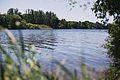 The Rideau river south of Barrhaven
 -
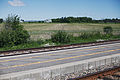 The railroad and farm on the north side of Barrhaven
 -
 Berry Glen Park in East Barrhaven


References
[edit]- ^ Population calculated by combining census tracts 5050140.03, 5050140.05, 5050140.04, 5050140.07, 5050140.06, 5050141.11, 5050141.10, 5050141.16, 5050141.17, 5050141.09, 5050141.18, 5050141.19, 5050141.20, 5050141.21, 5050141.22, 5050141.13, 5050141.04, 5050141.23, 5050141.24, 5050141.25, 5050141.26
- ^ a b c "10 Little-Known Facts about Barrhaven". The Barrhaven Blog. October 25, 2025. Archived from the original on November 17, 2025. Retrieved February 5, 2026.
- ^ a b "Barrhaven Fast Facts". Allthingshome. Archived from the original on September 10, 2025. Retrieved February 5, 2026.
- ^ a b "Document 5 Study Area – Neighbourhood Heritage Statement Attributes". Archived from the original on February 5, 2026. Retrieved February 5, 2026.
- ^ Desmond Kennedy. "Coming of the Rail Era" Archived 2011-07-23 at the Wayback Machine The Kennedy Story (transcribed by Taylor Kennedy) Accessed July 3, 2007.
- ^ "Ottawa's worst mass killing shocks and devastates Barrhaven, and the city". Ottawa Citizen. March 7, 2024. Retrieved March 7, 2024.
- ^ "Barrhaven: A Growing Suburban Gem in Ottawa's Southwest". Ottawa True North Realty. Archived from the original on February 5, 2026. Retrieved February 5, 2026.
- ^ "Why Barrhaven Is Perfect for Families, and How to Move There Seamlessly". Labelle Moving. September 13, 2025. Archived from the original on October 16, 2025. Retrieved February 5, 2026.
- ^ Abbas, Ali (October 1, 2025). "Barrhaven Ottawa A Community For Everyone". Aliabbas Real Estate. Archived from the original on February 5, 2026. Retrieved February 5, 2026.
- ^ Ali, Husnain (June 21, 2025). "🏡 Is Barrhaven the Best Suburb in Ottawa? Here's What You Need to Know". Ali Realty Group. Archived from the original on October 10, 2025. Retrieved February 5, 2026.
- ^ "5 Reasons to Buy a Home in Barrhaven". The Wright Team. July 31, 2023. Archived from the original on December 16, 2025. Retrieved February 5, 2026.
- ^ "Pros and cons of moving to Barrhaven". Professional Movers Ottawa. Archived from the original on September 10, 2025. Retrieved February 5, 2026.
- ^ "Minto launches Quinn's Pointe in Barrhaven". Retrieved 2015-10-05.
- ^ "Minto Recreation Complex - Barrhaven". ottawa.ca. Archived from the original on 1 December 2020. Retrieved 2015-10-06.
- ^ "Photos: Residents, VIPs turn out for opening of Barrhaven's Minto Recreation Complex". Ottawa Citizen. 29 November 2014. Archived from the original on 10 February 2018. Retrieved 28 April 2021.
- ^ "CitiGate - 416 Corporate Campus | regionalgroup.com". regionalgroup.com. Archived from the original on 2016-06-11. Retrieved 2016-05-17.
- ^ "Barrhaven South Urban Expansion Area - Community Design Plan" (PDF). Archived (PDF) from the original on February 5, 2026. Retrieved February 5, 2026.
- ^ http://www.octranspo.com/community-events/barrhaven_transplan[permanent dead link]
Further reading
[edit]- Melanie O'Brien. "Thriving beyond the greenbelt: Barrhaven growing rapidly as buyers look for a sense of community." The Ottawa Citizen. Jun 29, 1996. p. J.1
- Janet Collins. "The Far Haven: Barrhaven" The Ottawa Citizen. Feb 1, 1993. p. B.3
- Carrie Buchanan. "A sleeping suburb; Barrhaven's nothing but a bedroom community." The Ottawa Citizen. Oct 29, 1989. p. D.1
External links
[edit]![]() Media related to Barrhaven at Wikimedia Commons
Media related to Barrhaven at Wikimedia Commons
| History |
|
|---|---|
| Geography | |
| Culture | |
| Public services | |
| Education | |
| Government | |
| Transportation and infrastructure | |
| Features | |